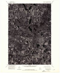
1974 Map of Balsam Lake NE
USGS Topo · Published 1976About this map
Glacial geology and agricultural development are captured through high-altitude aerial imagery in this orthophotograph of the northern Wisconsin interior. Taken on October 12, 1974, the imagery reveals a dense mosaic of cultivated fields, wooded woodlots, and deep glacial kettle lakes. This specific format, produced by the U.S. Geological Survey and the Wisconsin Geological and Natural History Survey, emphasizes the physical grain of the land over traditional cartographic symbols. The rectangular grid of the Public Land Survey System is clearly visible across the landscape, with a notable survey boundary labeled Range indicating the structured settlement patterns of Polk County. This specialized view is essential for understanding the distribution of wetlands and forest cover before late-century changes.
Find a feature on this map
1 named feature on this map. Tap any name to fly to it.
Don’t see what you’re looking for? This feature index may not catch every label — zoom into the map to look around manually.
Map Details
Editions of this 1974 Balsam Lake NE Map
This is the sole edition of this map. No revisions or reprints were ever made.
Other maps of this area

1950 · Balsam Lake
USGS Topo · 1:62,500

1950 · Turtle Lake
USGS Topo · 1:62,500

1951 · Cumberland
USGS Topo · 1:48,000

1951 · Frederic
USGS Topo · 1:48,000

1952 · Turtle Lake
USGS Topo · 1:62,500

1953 · Stillwater
USGS Topo · 1:250,000

1955 · Frederic
USGS Topo · 1:62,500

1955 · Stillwater
USGS Topo · 1:250,000

1956 · Cumberland
USGS Topo · 1:62,500

1958 · Stillwater
USGS Topo · 1:250,000