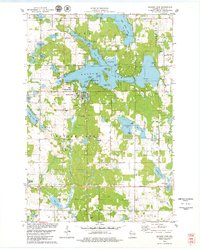
1978 Map of Balsam Lake
USGS Topo · Published 1979About this map
The village of Balsam Lake serves as the focal point of this late-1970s survey, where the Courthouse stands near the shore of its namesake water body. The lake itself is a complex of distinct basins and islands, including Boston Bay, Raskin Bay, and a cluster of landforms like Bear Island and Paradise Island. To the north, the terrain transitions into a dense network of smaller lakes such as Rice Lake and Half Moon Lake, while the eastern boundary is defined by the winding course of the Apple River.
Find a feature on this map
69 named features on this map. Tap any name to fly to it.
Don’t see what you’re looking for? This feature index may not catch every label — zoom into the map to look around manually.
Map Details
Editions of this 1978 Balsam Lake Map
This is the sole edition of this map. No revisions or reprints were ever made.
Other maps of this area

1900 · St Croix Dalles
USGS Topo · 1:62,500

1901 · St Croix Dalles
USGS Topo · 1:62,500

1950 · Balsam Lake
USGS Topo · 1:62,500

1951 · Milltown
USGS Topo · 1:48,000

1951 · Frederic
USGS Topo · 1:48,000

1953 · Stillwater
USGS Topo · 1:250,000

1955 · St. Croix Dalles
USGS Topo · 1:62,500

1955 · Frederic
USGS Topo · 1:62,500

1955 · Milltown
USGS Topo · 1:62,500

1955 · Stillwater
USGS Topo · 1:250,000