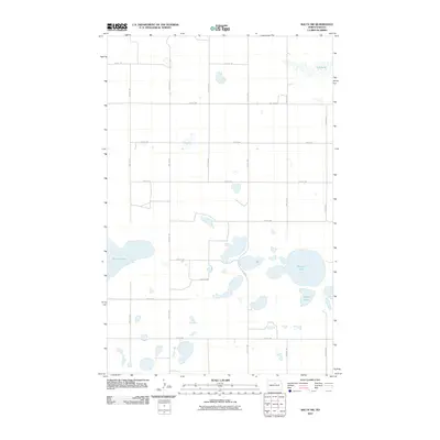
2011 Map of Balta NW
USGS Topo · Published 2011About this map
Kilgore Lake and the surrounding prairie potholes define this section of McHenry County, where the landscape is dominated by a complex network of glacial wetlands and seasonal water bodies. This 2011 survey illustrates the rural grid of North Dakota, where arterial gravel roads like 19th Ave NE and 54th St NE partition the land into expansive agricultural blocks. The hydrography of the region is notably diverse, ranging from the elongated waters of Red Lake in the northeast to the broad basin of Smoky Lake in the west. These basins serve as critical catchments in an area defined by internal drainage, where small, unnamed sloughs dot the sections between larger landmarks like Stony Lake. The map serves as a detailed record of the mid-continent's modern rural infrastructure, showing how township lines and section roads have adapted to the natural contours of the state's lake-strewn plains.
Find a feature on this map
18 named features on this map. Tap any name to fly to it.
Don’t see what you’re looking for? This feature index may not catch every label — zoom into the map to look around manually.
Map Details
Editions of this 2011 Balta NW Map
This is the sole edition of this map. No revisions or reprints were ever made.
Other maps of this area

1954 · Tunbridge
USGS Topo · 1:24,000

1954 · Berwick
USGS Topo · 1:24,000

1954 · Towner SE
USGS Topo · 1:24,000

1954 · Minot
USGS Topo · 1:250,000

1955 · Rangeley NE
USGS Topo · 1:24,000

1957 · Rangeley SE
USGS Topo · 1:24,000

1958 · Minot
USGS Topo · 1:250,000

1958 · Balta SE
USGS Topo · 1:24,000
1958 · Balta NW
USGS Topo · 1:24,000

1958 · Balta
USGS Topo · 1:24,000