
1958 Map of Balta
USGS Topo · Published 1959About this map
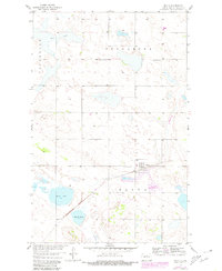
Balta serves as the central hub of this North Dakota landscape, situated along the Minneapolis St Paul and Sault Ste Marie railroad line. The map reveals a rural prairie environment organized by the township boundaries of Jefferson, Tuscarora, and Balta, where life revolved around small local schools and community burial grounds. Educational needs for the outlying farming families were met by institutions like Brazil Sch No 2 and Brazil Sch No 3, while the Mt Carmel Cem and another smaller Cem provided focal points for local genealogy. The geography is characterized by numerous water bodies, including Red Lake, Davis Lake, and Ranch Lake, which are scattered among the topographic depressions of the Missouri River Basin. This survey was produced as part of a mid-century Department of the Interior program focused on the development of this vital river basin.
Find a feature on this map
12 named features on this map. Tap any name to fly to it.
Don’t see what you’re looking for? This feature index may not catch every label — zoom into the map to look around manually.
Map Details
Editions of this 1958 Balta Map
2 editions found
Other maps of this area

1953 · Devils Lake
USGS Topo · 1:250,000

1954 · Tunbridge
USGS Topo · 1:24,000

1954 · Berwick
USGS Topo · 1:24,000

1954 · Minot
USGS Topo · 1:250,000

1955 · Rugby
USGS Topo · 1:24,000

1956 · Devils Lake
USGS Topo · 1:250,000

1958 · Minot
USGS Topo · 1:250,000

1958 · Balta SE
USGS Topo · 1:24,000
1958 · Balta NW
USGS Topo · 1:24,000
1958 · Orrin
USGS Topo · 1:24,000