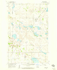
1958 Map of Orrin
USGS Topo · Published 1959About this map
Orrin serves as the central hub of this North Dakota prairie landscape, situated along the Minneapolis St Paul and Sault Ste Marie railroad. The map reflects a mid-century agricultural region defined by its glacial pothole geology, where numerous unnamed water bodies dot the terrain alongside Round Lake and the larger Antelope Lake to the south. Local heritage is rooted in the townships of Elling and Schiller, with the St Mathis Cem providing a genealogical anchor for the community. The presence of a Sandpit near the rail line suggests small-scale local industry supporting regional infrastructure. Tracing the boundary between McHenry and Pierce Counties, the map illustrates a network of section-line roads connecting isolated farmsteads across the high plains of the Missouri River Basin development area.
Find a feature on this map
9 named features on this map. Tap any name to fly to it.
Don’t see what you’re looking for? This feature index may not catch every label — zoom into the map to look around manually.
Map Details
Editions of this 1958 Orrin Map
This is the sole edition of this map. No revisions or reprints were ever made.
Other maps of this area

1930 · Drake
USGS Topo · 1:62,500

1940 · Aylmer
USGS Topo · 1:62,500

1954 · Minot
USGS Topo · 1:250,000

1954 · McClusky
USGS Topo · 1:250,000

1955 · Rangeley NE
USGS Topo · 1:24,000

1957 · Rangeley SE
USGS Topo · 1:24,000

1958 · McClusky
USGS Topo · 1:250,000

1958 · Minot
USGS Topo · 1:250,000
1958 · Anamoose
USGS Topo · 1:24,000

1958 · Balta SE
USGS Topo · 1:24,000