
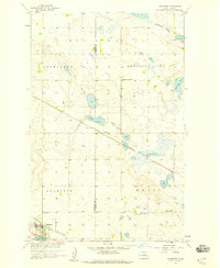
1957 Map of Rangeley SE
USGS Topo · Published 1958About this map
Glacial prairie potholes dominate this North Dakota landscape during the late 1950s, creating a complex network of wetlands and seasonal water bodies. The rural social fabric of McHenry County is clearly visible through the placement of localized institutions, such as St Johns Ch and its accompanying St Johns Cem. Education in this period was distributed across small district facilities, including Long Lake Sch No 1, Long Lake Sch No 2, and Seehafer Sch, illustrating a decentralized community structure.
Find a feature on this map
21 named features on this map. Tap any name to fly to it.
Don’t see what you’re looking for? This feature index may not catch every label — zoom into the map to look around manually.
Map Details
Editions of this 1957 Rangeley SE Map
This is the sole edition of this map. No revisions or reprints were ever made.
Other maps of this area

1930 · Drake
USGS Topo · 1:62,500

1940 · Aylmer
USGS Topo · 1:62,500

1954 · Minot
USGS Topo · 1:250,000

1954 · McClusky
USGS Topo · 1:250,000

1955 · Rangeley NW
USGS Topo · 1:24,000

1955 · Rangeley NE
USGS Topo · 1:24,000

1957 · Rangeley
USGS Topo · 1:24,000

1958 · McClusky
USGS Topo · 1:250,000

1958 · Minot
USGS Topo · 1:250,000
1958 · Anamoose
USGS Topo · 1:24,000