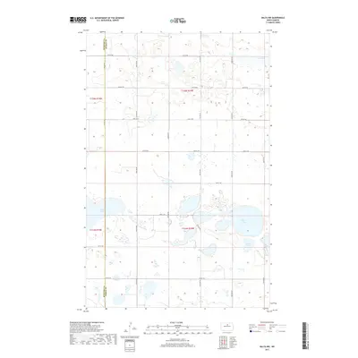
2017 Map of Balta NW
USGS Topo · Published 2017About this map
Glacial prairie potholes and scattered wetlands define this portion of the North Dakota landscape along the boundary of McHenry Co and Pierce Co. This 2017 survey reveals a terrain dominated by significant water bodies, including the expansive Smoky Lake in the southwest and the adjacent Kilgore Lake and Stony Lake to the east. The systematic section lines of the Public Land Survey System are clearly visible, with gravel roads like 57th St NE and 50th St NE providing a geometric framework across the undulating plains. Further north, the edge of Red Lake appears, illustrating the density of these natural basins which are characteristic of the region's hydrography. The map serves as a precise record of the rural road network and the complex interplay of water and land in this agricultural heartland.
Find a feature on this map
17 named features on this map. Tap any name to fly to it.
Don’t see what you’re looking for? This feature index may not catch every label — zoom into the map to look around manually.
Map Details
Editions of this 2017 Balta NW Map
This is the sole edition of this map. No revisions or reprints were ever made.
Other maps of this area

1954 · Tunbridge
USGS Topo · 1:24,000

1954 · Berwick
USGS Topo · 1:24,000

1954 · Towner SE
USGS Topo · 1:24,000

1954 · Minot
USGS Topo · 1:250,000

1955 · Rangeley NE
USGS Topo · 1:24,000

1957 · Rangeley SE
USGS Topo · 1:24,000

1958 · Minot
USGS Topo · 1:250,000

1958 · Balta SE
USGS Topo · 1:24,000
1958 · Balta NW
USGS Topo · 1:24,000

1958 · Balta
USGS Topo · 1:24,000