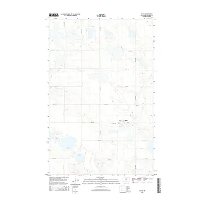
2014 Map of Balta
USGS Topo · Published 2014About this map
The small prairie community of Balta serves as the central hub for this portion of Pierce County, characterized by the glacial depressions and wetlands common to the North Dakota landscape. The map highlights key local landmarks such as Mt Carmel Cem just west of the town center, providing a vital point of reference for genealogists and local historians. The surrounding terrain is defined by significant bodies of water, including the large Davis Lake to the southwest, alongside Red Lake and Ranch Lake. A grid of section-line roads like 24th Ave NE and 50th St NE organizes the agricultural expanse, while CR-3526 provides the primary paved connection through the heart of the settlement. This 2014 survey captures the persistence of these small-town rural centers amidst a landscape of changing water levels and vast agricultural fields.
Find a feature on this map
20 named features on this map. Tap any name to fly to it.
Don’t see what you’re looking for? This feature index may not catch every label — zoom into the map to look around manually.
Map Details
Editions of this 2014 Balta Map
This is the sole edition of this map. No revisions or reprints were ever made.
Other maps of this area

1953 · Devils Lake
USGS Topo · 1:250,000

1954 · Tunbridge
USGS Topo · 1:24,000

1954 · Berwick
USGS Topo · 1:24,000

1954 · Minot
USGS Topo · 1:250,000

1955 · Rugby
USGS Topo · 1:24,000

1956 · Devils Lake
USGS Topo · 1:250,000

1958 · Minot
USGS Topo · 1:250,000

1958 · Balta SE
USGS Topo · 1:24,000
1958 · Balta NW
USGS Topo · 1:24,000

1958 · Balta
USGS Topo · 1:24,000