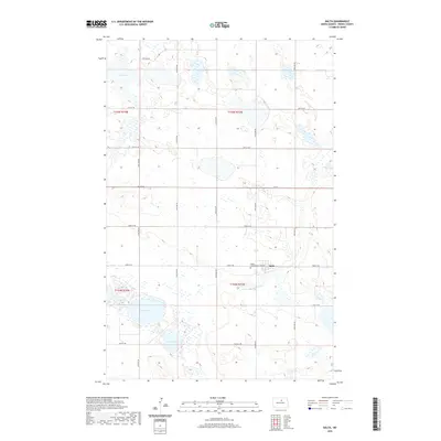
2020 Map of Balta
USGS Topo · Published 2020About this map
Balta and its surrounding prairie wetlands define this corner of Pierce County, where a grid of rural section lines creates a rhythmic pattern across the landscape. The settlement itself is centered near the intersection of 2nd Ave and 52nd St NE, serving as a hub for the scattered homesteads of the region. Local history is anchored at the Mount Carmel Cem, located just west of the town center. The terrain is characterized by numerous glacial depressions, most notably Red Lake, Davis Lake, and Ranch Lake, which interrupt the agricultural geometry. These water bodies, along with the extensive network of wetlands identified by the FWS National Wetlands Inventory, reflect a landscape where the natural hydrography and human-made road network must coexist. The prevalence of numbered roads like 24th Ave NE and 56th St NE underscores the precision of the Public Land Survey System in organizing this North Dakota territory.
Find a feature on this map
23 named features on this map. Tap any name to fly to it.
Don’t see what you’re looking for? This feature index may not catch every label — zoom into the map to look around manually.
Map Details
Editions of this 2020 Balta Map
This is the sole edition of this map. No revisions or reprints were ever made.
Other maps of this area

1953 · Devils Lake
USGS Topo · 1:250,000

1954 · Tunbridge
USGS Topo · 1:24,000

1954 · Berwick
USGS Topo · 1:24,000

1954 · Minot
USGS Topo · 1:250,000

1955 · Rugby
USGS Topo · 1:24,000

1956 · Devils Lake
USGS Topo · 1:250,000

1958 · Minot
USGS Topo · 1:250,000

1958 · Balta SE
USGS Topo · 1:24,000
1958 · Balta NW
USGS Topo · 1:24,000

1958 · Balta
USGS Topo · 1:24,000