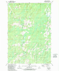
1989 Map of Banat
USGS Topo · Published 1989About this map
Escanaba River State Forest covers much of this landscape in the late 1980s, revealing a region defined by its timber heritage and hydrological network. Small settlements like Banat, Nathan, and Gardner provide evidence of early 20th-century colonization efforts in the Upper Peninsula, particularly by European immigrants. The transportation history of the area is etched into the terrain by an Old Railroad Grade and Old RR Gr, which once moved timber and resources across the county. Numerous water bodies including the Little Cedar River, Shakey River, and Wire Grass Lake dominate the drainage pattern, while scattered Gravel Pits indicate local industry. This survey by the Michigan Department of Natural Resources and the USGS captures the transition from active extraction to managed state forestry.
Find a feature on this map
25 named features on this map. Tap any name to fly to it.
Don’t see what you’re looking for? This feature index may not catch every label — zoom into the map to look around manually.
Map Details
Editions of this 1989 Banat Map
This is the sole edition of this map. No revisions or reprints were ever made.
Other maps of this area

1939 · Pembine
USGS Topo · 1:48,000

1942 · Wausaukee
USGS Topo · 1:48,000

1947 · Pembine
USGS Topo · 1:48,000

1947 · Wausaukee
USGS Topo · 1:48,000

1949 · Stephenson
USGS Topo · 1:48,000

1954 · Escanaba
USGS Topo · 1:250,000

1957 · Escanaba
USGS Topo · 1:250,000

1958 · Escanaba
USGS Topo · 1:250,000

1963 · Pembine
USGS Topo · 1:62,500

1963 · Powers
USGS Topo · 1:62,500