
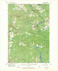
1963 Map of Pembine
USGS Topo · Published 1964About this map
The Menominee River defines the winding border between Wisconsin and Michigan, creating a landscape shaped by water and industry in the early 1960s. Rail transport remains central to the region's geography, with the Chicago and North Western and Soo Line tracks intersecting near Pembine. This junction, along with the nearby Hillcrest Cem and Pembine Cem, marks the historical heart of the local community.
Find a feature on this map
96 named features on this map. Tap any name to fly to it.
Don’t see what you’re looking for? This feature index may not catch every label — zoom into the map to look around manually.
Map Details
Editions of this 1963 Pembine Map
2 editions found
Other maps of this area

1939 · Pembine
USGS Topo · 1:48,000

1939 · Dunbar
USGS Topo · 1:48,000

1939 · Iron Mountain
USGS Topo · 1:48,000

1940 · Athelstane
USGS Topo · 1:48,000

1941 · Dunbar
USGS Topo · 1:48,000

1941 · Iron Mountain
USGS Topo · 1:48,000

1942 · Athelstane
USGS Topo · 1:48,000

1942 · Wausaukee
USGS Topo · 1:48,000

1947 · Pembine
USGS Topo · 1:48,000

1947 · Dunbar
USGS Topo · 1:48,000