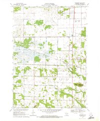
1970 Map of Bancroft
USGS Topo · Published 1972About this map
Bancroft and its smaller neighbor West Bancroft serve as central points in this central Wisconsin landscape during the early 1970s. The agricultural character of the region is defined by an extensive network of drainage infrastructure, with numbered features such as Ditch No 8 and Ditch No 3 carving through the marshy terrain of Buena Vista and Pine Grove. The Chicago and North Western railroad provides a clear industrial corridor, passing near the Gaging Station and cutting through the eastern portion of the quadrangle. Local landmarks like The Ledge and Mosquito Bluff break the relatively flat topography, while family history is rooted at the Pine Grove Cem. Tracing the paths of the North Branch Tenmile Creek and South Branch Tenmile Creek reveals the natural hydrology that shaped local land use and the development of surrounding hamlets like Coddington.
Find a feature on this map
30 named features on this map. Tap any name to fly to it.
Don’t see what you’re looking for? This feature index may not catch every label — zoom into the map to look around manually.
Map Details
Editions of this 1970 Bancroft Map
2 editions found
Other maps of this area

1955 · Green Bay
USGS Topo · 1:250,000

1957 · Amherst
USGS Topo · 1:48,000

1957 · Whiting
USGS Topo · 1:48,000

1958 · Coloma
USGS Topo · 1:48,000

1959 · Wautoma
USGS Topo · 1:48,000

1968 · Coloma NW
USGS Topo · 1:24,000

1968 · Plainfield
USGS Topo · 1:24,000

1968 · Hancock
USGS Topo · 1:24,000

1969 · Arnott
USGS Topo · 1:24,000
1969 · Almond
USGS Topo · 1:24,000