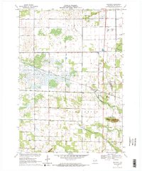
1970 Map of Bancroft
USGS Topo · Published 1972About this map
Bancroft and West Bancroft serve as the primary nodes of settlement in this central Wisconsin landscape, situated along the Chicago and North Western railroad line. The terrain is defined by the flat, marshy reaches of Buena Vista and Pine Grove, where a complex network of drainage ditches and canals regulates the flow of Duck Creek and the bifurcated North Branch and South Branch Tenmile Creek. These engineering efforts transformed the wetland character of the region into productive land, a transition visible in the orderly grid of local routes like Lake Road and Mill Road. Prominent natural landmarks rise above the plain, including Mosquito Bluff and the geological formation known as The Ledge. Genealogists will find the Pine Grove Cem and smaller hamlets like Coddington noted, documenting the community footprint in Portage County during the early 1970s.
Find a feature on this map
21 named features on this map. Tap any name to fly to it.
Don’t see what you’re looking for? This feature index may not catch every label — zoom into the map to look around manually.
Map Details
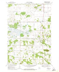
Editions of this 1970 Bancroft Map
2 editions found
Other maps of this area

1955 · Green Bay
USGS Topo · 1:250,000

1957 · Amherst
USGS Topo · 1:48,000

1957 · Whiting
USGS Topo · 1:48,000

1958 · Coloma
USGS Topo · 1:48,000

1959 · Wautoma
USGS Topo · 1:48,000

1968 · Coloma NW
USGS Topo · 1:24,000

1968 · Plainfield
USGS Topo · 1:24,000

1968 · Hancock
USGS Topo · 1:24,000

1969 · Arnott
USGS Topo · 1:24,000
1969 · Almond
USGS Topo · 1:24,000