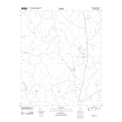
2011 Map of Bankston
USGS Topo · Published 2011About this map
Bankston and the surrounding Fayette County landscape are defined by a network of creeks and small settlements in this 2011 survey. The community at Bankston is anchored by the Bankston Post Office, while the neighboring rural areas of Stough and Cleveland maintain their historic character. The map reveals the local energy economy through the Bankston Gas Field and Berry Junction Gas Field, which are interspersed among the drainages of Deadwater Creek and the North River. For genealogists, the map is particularly rich in burial sites, documenting local family and community history at Philadelphia Cemetery, Bethel Cemetery, Zion Cemetery, and Pleasant Hill Cemetery. Water features like Bugs Lake and the Fayette County Lake provide focal points for the terrain, while numerous secondary roads such as Morris Loop Rd and Hershell Henry Rd suggest a landscape shaped by decades of agricultural and resource-based development.
Find a feature on this map
83 named features on this map. Tap any name to fly to it.
Don’t see what you’re looking for? This feature index may not catch every label — zoom into the map to look around manually.
Map Details
Editions of this 2011 Bankston Map
This is the sole edition of this map. No revisions or reprints were ever made.
Other maps of this area

1953 · Birmingham
USGS Topo · 1:250,000

1956 · Birmingham
USGS Topo · 1:250,000

1957 · Birmingham
USGS Topo · 1:250,000

1967 · Bankston
USGS Topo · 1:24,000

1967 · Winfield SE
USGS Topo · 1:24,000

1967 · Newtonville
USGS Topo · 1:24,000

1967 · Hubbertville
USGS Topo · 1:24,000
1967 · Berry
USGS Topo · 1:24,000

1967 · Fayette
USGS Topo · 1:24,000
1967 · New Lexington
USGS Topo · 1:24,000