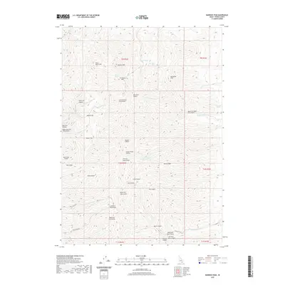
2020 Map of Bannock Peak
USGS Topo · Published 2020About this map
Bannock Peak and Moonshine Peak anchor this high-elevation landscape in Power County, where the terrain is defined by a dense network of drainages and named canyon systems. The hydrological patterns here include several isolated water sources such as Bannock Spring, Cabin Springs, and Dry Hollow Spring, which likely served as critical points for cattle and wildlife in this semi-arid environment. The presence of Upper Stump Canyon Reservoir suggests managed water resources in an area otherwise dominated by seasonal creeks like Sawmill Cr and W Fork Bannock Cr.
Find a feature on this map
48 named features on this map. Tap any name to fly to it.
Don’t see what you’re looking for? This feature index may not catch every label — zoom into the map to look around manually.
Map Details
Editions of this 2020 Bannock Peak Map
This is the sole edition of this map. No revisions or reprints were ever made.
Other maps of this area

1934 · Rockland
USGS Topo · 1:62,500

1937 · Rockland
USGS Topo · 1:62,500

1938 · Pauline
USGS Topo · 1:48,000

1944 · Arbon
USGS Topo · 1:62,500

1954 · Pocatello
USGS Topo · 1:250,000

1958 · Pocatello
USGS Topo · 1:250,000

1971 · Rockland East
USGS Topo · 1:24,000

1971 · Bannock Peak
USGS Topo · 1:24,000
1971 · Flatiron Hill
USGS Topo · 1:24,000
1971 · Sawmill Creek
USGS Topo · 1:24,000