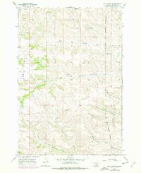
1967 Map of Bar V Ranch NE
USGS Topo · Published 1978About this map
The Crow Indian Reservation Boundary bisects this landscape of the Big Horn region, where the eastern slopes of the Wolf Mountains drop toward a complex drainage network. This 1967 field-checked survey reveals an area defined by its water sources, with the North Fork Rosebud Creek and South Fork Rosebud Creek carving deep paths through the high country.
Find a feature on this map
11 named features on this map. Tap any name to fly to it.
Don’t see what you’re looking for? This feature index may not catch every label — zoom into the map to look around manually.
Map Details
Editions of this 1967 Bar V Ranch NE Map
2 editions found
Other maps of this area

1894 · Rosebud
USGS Topo · 1:125,000

1901 · Rosebud
USGS Topo · 1:125,000

1954 · Hardin
USGS Topo · 1:250,000

1957 · Hardin
USGS Topo · 1:250,000

1958 · Hardin
USGS Topo · 1:250,000

1967 · Kid Creek
USGS Topo · 1:24,000

1967 · Wolf Mountain Lookout
USGS Topo · 1:24,000

1967 · Kirby
USGS Topo · 1:24,000

1967 · Bar V Ranch NE
USGS Topo · 1:24,000
1967 · Bar V Ranch
USGS Topo · 1:24,000