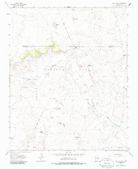
1963 Map of Bar Y Ranch
USGS Topo · Published 1985About this map
The Preston Beck Grant and the eastern edge of the Anton Chico Grant define the land divisions of this high-plateau landscape in the early 1960s. Ranching infrastructure is the primary mark of human activity, centered on operations like the Bar Y Ranch and Cowden Ranch. The scarcity of water in this arid environment is evident in the extensive network of named wells, tanks, and seasonal lakes, including Sabino Lake, Puertocito Lake, and Sabino Springs. Topography is marked by a significant Dome and the winding Esteros Creek, which cuts through the terrain toward the southern reaches of the map. A modern Pipeline crosses the lower portion of the sheet, providing a stark contrast to the historical land grant boundaries and the network of unimproved dirt roads that connect remote water sources like Box Canyon Well and Vaughn Well.
Find a feature on this map
27 named features on this map. Tap any name to fly to it.
Don’t see what you’re looking for? This feature index may not catch every label — zoom into the map to look around manually.
Map Details
Editions of this 1963 Bar Y Ranch Map
2 editions found
Other maps of this area

1892 · Corazon
USGS Topo · 1:125,000

1894 · Corazon
USGS Topo · 1:125,000

1954 · Santa Fe
USGS Topo · 1:250,000

1958 · Santa Fe
USGS Topo · 1:250,000

1963 · Colonias
USGS Topo · 1:24,000

1963 · Cactus Tank
USGS Topo · 1:24,000

1963 · Mesa Cherisco
USGS Topo · 1:24,000

1963 · Sacaton Draw
USGS Topo · 1:24,000
1963 · Horse Pasture Tank
USGS Topo · 1:24,000
1963 · Catfish Falls
USGS Topo · 1:24,000