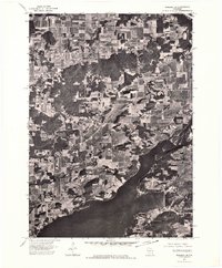
1974 Map of Baraboo NE
USGS Topo · Published 1976About this map
Lake Wisconsin dominates the southern landscape of this mid-1970s orthophotoquad, where the broad waters of the Wisconsin River broaden into a major reservoir. This photographic record, derived from 1974 aerial surveys, provides a clear visual of the land use patterns along the Columbia County shoreline during a period of transition. The imagery reveals the intricate mosaic of woodlots and geometric agricultural fields that characterize this portion of the river valley. The high-contrast black-and-white photography allows for a precise examination of the forest edges and riparian zones, showing how the local topography was managed for farming and recreation decades ago. It serves as a literal visual baseline for the region's shoreline development and rural field patterns.
Find a feature on this map
2 named features on this map. Tap any name to fly to it.
Don’t see what you’re looking for? This feature index may not catch every label — zoom into the map to look around manually.
Map Details
Editions of this 1974 Baraboo NE Map
This is the sole edition of this map. No revisions or reprints were ever made.
Other maps of this area

1895 · Baraboo
USGS Topo · 1:62,500

1901 · Poynette
USGS Topo · 1:62,500

1902 · Portage
USGS Topo · 1:62,500

1902 · Briggsville
USGS Topo · 1:62,500

1908 · Baraboo
USGS Topo · 1:62,500

1957 · Madison
USGS Topo · 1:250,000

1958 · Briggsville
USGS Topo · 1:62,500

1959 · Baraboo
USGS Topo · 1:62,500

1960 · Madison
USGS Topo · 1:250,000

1962 · Poynette
USGS Topo · 1:62,500