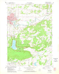
1975 Map of Baraboo
USGS Topo · Published 1978About this map
The Baraboo River winds through the heart of the Baraboo valley, defining a landscape where mid-century urban expansion met preserved glacial history. In the mid-1970s, the city core is dense with civic infrastructure including the Courthouse, St Clare Hospital, and schools such as Jr High Sch. To the north, the International Crane Foundation and Man Mound Park signal the area's dedication to both conservation and ancient history. The southern half of the map is dominated by the dramatic topography of the Baraboo Range, encompassing Devils Lake State Park and the Ice Age National Scientific Reserve. This area showcases the sheer West Bluff and East Bluff surrounding Devils Lake, transitioning into the industrial footprint of the Badger Army Ammunition Plant at the southern boundary. Traces of early settlement remain visible through numerous rural burial grounds like Jones Cem and Brewster Cem.
Find a feature on this map
57 named features on this map. Tap any name to fly to it.
Don’t see what you’re looking for? This feature index may not catch every label — zoom into the map to look around manually.
Map Details
Editions of this 1975 Baraboo Map
2 editions found
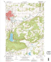
Other maps of this area

1895 · Baraboo
USGS Topo · 1:62,500

1901 · Denzer
USGS Topo · 1:62,500

1901 · The Dells
USGS Topo · 1:62,500

1902 · Briggsville
USGS Topo · 1:62,500

1908 · Baraboo
USGS Topo · 1:62,500

1957 · Wisconsin Dells
USGS Topo · 1:62,500

1957 · Madison
USGS Topo · 1:250,000

1958 · Briggsville
USGS Topo · 1:62,500

1958 · North Freedom
USGS Topo · 1:62,500

1959 · Baraboo
USGS Topo · 1:62,500