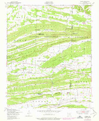
1947 Map of Barber
USGS Topo · Published 1978About this map
Camp Chaffee Military Reservation dominates the northern half of this landscape, a significant installation straddling the borders of Franklin, Sebastian, and Logan counties. The terrain is defined by a series of parallel ridges including Devils Backbone Mountain, Washburn Ridge, and the White Oak Mountains, which create natural corridors like Backbone Narrows and Bradshaw Narrows. These gaps in the ridge-lines have historically channeled movement and settlement through the valley floors.
Find a feature on this map
33 named features on this map. Tap any name to fly to it.
Don’t see what you’re looking for? This feature index may not catch every label — zoom into the map to look around manually.
Map Details
Editions of this 1947 Barber Map
2 editions found
Other maps of this area

1887 · Magazine Mountain #2
USGS Topo · 1:62,500

1887 · Magazine Mountain #3
USGS Topo · 1:62,500

1887 · Magazine Mountain
USGS Topo · 1:62,500

1890 · Magazine Mountain
USGS Topo · 1:125,000

1890 · Fort Smith
USGS Topo · 1:125,000

1906 · Lavaca
USGS Topo · 1:62,500

1906 · Barber
USGS Topo · 1:62,500

1934 · Booneville
USGS Topo · 1:48,000

1939 · Booneville
USGS Topo · 1:62,500

1943 · Fort Smith
USGS Topo · 1:125,000