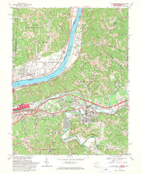
1968 Map of Barboursville
USGS Topo · Published 1970About this map
The Ohio River forms a wide natural boundary between Ohio and West Virginia, serving as the central artery for this late-1960s landscape. On the West Virginia side, the Guyandotte River meanders toward Huntington, passing through Barboursville where industrial infrastructure like a Sewage Disposal Pond sits near residential expansion. The era's transportation network is defined by the Baltimore and Ohio and Chesapeake and Ohio railroads, which parallel the riverbanks and support the movement of coal and freight.
Find a feature on this map
72 named features on this map. Tap any name to fly to it.
Don’t see what you’re looking for? This feature index may not catch every label — zoom into the map to look around manually.
Map Details
Editions of this 1968 Barboursville Map
3 editions found
Other maps of this area

1892 · Huntington
USGS Topo · 1:125,000

1898 · Huntington
USGS Topo · 1:125,000

1901 · Guyandot
USGS Topo · 1:62,500

1902 · Guyandot
USGS Topo · 1:62,500

1902 · Milton
USGS Topo · 1:62,500

1906 · Athalia
USGS Topo · 1:62,500

1906 · Glenwood
USGS Topo · 1:62,500

1908 · Athalia
USGS Topo · 1:62,500

1908 · Glenwood
USGS Topo · 1:62,500

1931 · Milton
USGS Topo · 1:62,500