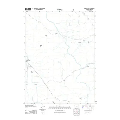
2012 Map of Barcus Peak
USGS Topo · Published 2012About this map
The N. Platte River winds through the heart of this high-country landscape, where a series of historic family ranching operations have shaped the Carbon County terrain. Agricultural life is centered around the valley floor, supported by irrigation projects like Barcus Ditch and Rocky Point Ditch. Established holdings such as Sanger Ranch, Jenkins Ranch, and Platt Ranch are connected by gravel arteries including French Creek Rd and Skyline Rd. The presence of the Platt Cem and private landing strips like the Platt Ranch Airport indicate the self-sufficient nature of these remote settlements. Beyond the water-rich bottoms, the land rises toward Barcus Peak and the Beaver Creek Hills, a region defined by numerous draws and gulches such as Sanger Draw and Big Hollow Gulch.
Find a feature on this map
42 named features on this map. Tap any name to fly to it.
Don’t see what you’re looking for? This feature index may not catch every label — zoom into the map to look around manually.
Map Details
Editions of this 2012 Barcus Peak Map
This is the sole edition of this map. No revisions or reprints were ever made.
Other maps of this area

1906 · Medicine Bow
USGS Topo · 1:125,000

1908 · Medicine Bow
USGS Topo · 1:125,000

1939 · Saratoga
USGS Topo · 1:125,000

1954 · Rawlins
USGS Topo · 1:250,000

1958 · Rawlins
USGS Topo · 1:250,000
1961 · Elkhorn Point
USGS Topo · 1:24,000

1961 · Overlook Hill
USGS Topo · 1:24,000

1961 · Ryan Park
USGS Topo · 1:24,000

1961 · Gunst Reservoir
USGS Topo · 1:24,000
1961 · Trent Creek
USGS Topo · 1:24,000