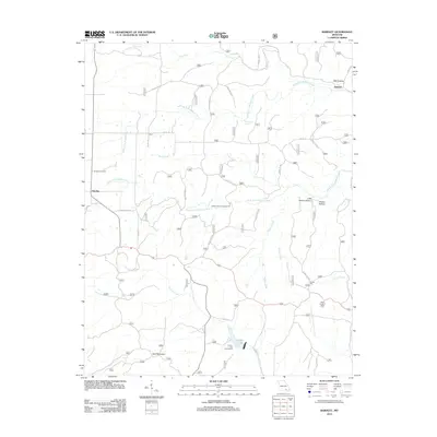
2012 Map of Bardley
USGS Topo · Published 2012About this map
Bardley and its nearby Bardley Cemetery anchor the western edge of this Ozark landscape, where the terrain is defined by the intricate branching of the North Fork Buffalo Creek and South Fork Buffalo Creek. The settlement of Bennett sits in the northeast corner near Mill Hollow, reflecting the rural social geography of Ripley County. The map reveals a heavily managed forest environment, crisscrossed by numerous routes such as Co RD J-2 and Forest RD 4864. Recreational and utility landmarks are prominent, including the Buffalo Creek Campground and the Briar Lookout Tower overlooking the drainage of North Fork Fourche Creek. To the south, Fourche Lake provides a focal point for water access, while named features like Wolf Mountain and Blue Hole Spring point to the specific local topography and natural springs that have long drawn residents and travelers to this part of Missouri.
Find a feature on this map
79 named features on this map. Tap any name to fly to it.
Don’t see what you’re looking for? This feature index may not catch every label — zoom into the map to look around manually.
Map Details
Editions of this 2012 Bardley Map
This is the sole edition of this map. No revisions or reprints were ever made.
Other maps of this area

1939 · Doniphan
USGS Topo · 1:62,500

1941 · Gatewood
USGS Topo · 1:62,500

1944 · Van Buren
USGS Topo · 1:62,500

1944 · Grandin
USGS Topo · 1:62,500

1945 · Doniphan
USGS Topo · 1:62,500

1945 · Gatewood
USGS Topo · 1:62,500

1946 · Grandin
USGS Topo · 1:62,500

1946 · Van Buren
USGS Topo · 1:62,500

1957 · Poplar Bluff
USGS Topo · 1:250,000

1959 · Poplar Bluff
USGS Topo · 1:250,000