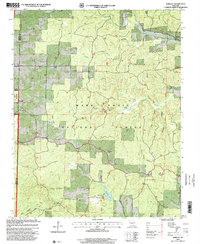
1997 Map of Bardley
USGS Topo · Published 2000About this map
Mark Twain National Forest dominates this landscape in the late 1990s, where the boundary of Oregon Co and Ripley Co meets amidst a network of limestone-carved drainages. Small settlements like Bardley and Pine persist along the winding ridge roads, serving as anchors for the local community. The presence of the Pine School and Bardley Church alongside Oak Ridge Church reflects the area’s enduring rural social structure. Topographical interest is found in the deep incisions of Buffalo Creek and the unusual Blue Hole Spring, while Fourche Lake and the Briar Lookout provide clear evidence of forest management and recreational land use during this period. The terrain, punctuated by features like Wolf Mountain and various hollows such as Sleuter Hollow, illustrates the complex geography of the southern Ozarks before the turn of the millennium.
Find a feature on this map
25 named features on this map. Tap any name to fly to it.
Don’t see what you’re looking for? This feature index may not catch every label — zoom into the map to look around manually.
Map Details
Editions of this 1997 Bardley Map
This is the sole edition of this map. No revisions or reprints were ever made.
Other maps of this area

1939 · Doniphan
USGS Topo · 1:62,500

1941 · Gatewood
USGS Topo · 1:62,500

1944 · Van Buren
USGS Topo · 1:62,500

1944 · Grandin
USGS Topo · 1:62,500

1945 · Doniphan
USGS Topo · 1:62,500

1945 · Gatewood
USGS Topo · 1:62,500

1946 · Grandin
USGS Topo · 1:62,500

1946 · Van Buren
USGS Topo · 1:62,500

1957 · Poplar Bluff
USGS Topo · 1:250,000

1959 · Poplar Bluff
USGS Topo · 1:250,000