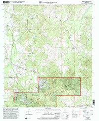
2000 Map of Barlow
USGS Topo · Published 2002About this map
The tiny settlement of Barlow sits at the center of this landscape, where the ridges of southwestern Mississippi meet the northern reaches of the Homochitto National Forest. Compiled from surveys dating back to the late 1950s and updated at the turn of the millennium, this map documents a rural network of family-named roads and remote country churches. Genealogists will find a high concentration of burial sites and community centers scattered across the hills, including Shelton Cem, Weeks Cem, and the Hickory Flat Ch cemetery. The terrain is defined by the winding paths of Little Pierre Bayou and Brandywine Creek, while the boundaries of Copiah, Claiborne, and Jefferson counties converge in the southwest. This record of the land preserves the locations of local landmarks like Macedonia Ch and Salem Ch before the further encroachment of modern timber management.
Find a feature on this map
27 named features on this map. Tap any name to fly to it.
Don’t see what you’re looking for? This feature index may not catch every label — zoom into the map to look around manually.
Map Details
Editions of this 2000 Barlow Map
This is the sole edition of this map. No revisions or reprints were ever made.
Other maps of this area

1953 · Natchez
USGS Topo · 1:250,000

1956 · Natchez
USGS Topo · 1:250,000

1959 · Natchez
USGS Topo · 1:250,000

1963 · Dentville NW
USGS Topo · 1:24,000

1963 · Dentville
USGS Topo · 1:24,000

1963 · Smyrna
USGS Topo · 1:24,000

1963 · Union Church
USGS Topo · 1:62,500
1963 · Hermanville
USGS Topo · 1:24,000

1963 · McBride
USGS Topo · 1:24,000

1963 · Barlow
USGS Topo · 1:24,000