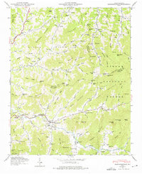
1946 Map of Barnardsville
USGS Topo · Published 1975About this map
Barnardsville serves as a primary hub in this mountain landscape, situated at the confluence of several branches of Ivy Creek. The area is defined by a deep network of family names etched into the terrain via numerous burial grounds, including the Whitaker Cem, Ballard Cem, and Marshbanks Cem. In the mid-1940s, the community structure centered on local congregations like the Antioch Ch and Democrat Ch, while the FFA Camp south of Dillingham points to the importance of agricultural education in the region. Much of the eastern and southern portion of the map is dominated by the Pisgah National Forest, where the elevation rises sharply toward peaks like Ivy Knob and Pinnacle Mtn. This period shows the rugged transition between the valley settlements and the high ridges of Chestnut Mountain and Burt Mountain, connected by gaps such as Wolfpit Gap and Phipps Gap.
Find a feature on this map
108 named features on this map. Tap any name to fly to it.
Don’t see what you’re looking for? This feature index may not catch every label — zoom into the map to look around manually.
Map Details
Editions of this 1946 Barnardsville Map
4 editions found
Other maps of this area

1894 · Asheville
USGS Topo · 1:125,000

1900 · Mount Mitchell
USGS Topo · 1:125,000

1901 · Asheville
USGS Topo · 1:125,000

1902 · Mount Mitchell
USGS Topo · 1:125,000

1935 · Montreat
USGS Topo · 1:24,000

1935 · Black Brothers
USGS Topo · 1:24,000

1935 · Burnsville
USGS Topo · 1:24,000

1935 · Bald Creek
USGS Topo · 1:24,000

1935 · Barnardsville
USGS Topo · 1:24,000

1935 · Craggy Pinnacle
USGS Topo · 1:24,000