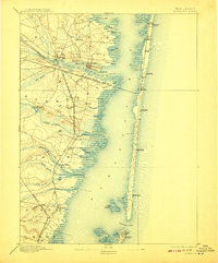
1898 Map of Barnegat
USGS Topo · Published 1908About this map
Barnegat Bay dominates this coastal survey, appearing just before the 20th century as a complex landscape of salt marshes, barrier islands, and emerging rail depots. The Philadelphia and Long Branch Railroad (Penn. R.R.) crosses the bay to reach the thin strip of land at Seaside Park, connecting the mainland to the Atlantic shore. Inland, the pine forests and cedar swamps are punctuated by uniquely named settlements like Double Trouble and Good Luck, while the mouth of Toms River shows established communities like Island Heights.
Find a feature on this map
55 named features on this map. Tap any name to fly to it.
Don’t see what you’re looking for? This feature index may not catch every label — zoom into the map to look around manually.
Map Details
Editions of this 1898 Barnegat Map
5 editions found

Other maps of this area

1884 · Whitings
USGS Topo · 1:62,500

1888 · Barnegat
USGS Topo · 1:62,500

1888 · Little Egg Harbor
USGS Topo · 1:62,500

1888 · Asbury Park
USGS Topo · 1:62,500

1888 · Cassville
USGS Topo · 1:62,500

1888 · Long Beach
USGS Topo · 1:62,500

1888 · Whitings
USGS Topo · 1:62,500

1893 · Little Egg Harbor
USGS Topo · 1:62,500

1893 · Asbury Park
USGS Topo · 1:62,500

1893 · Long Beach
USGS Topo · 1:62,500