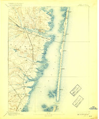
1898 Map of Barnegat
USGS Topo · Published 1917About this map
Barnegat Bay dominates this coastal landscape, separated from the Atlantic by a narrow barrier island dotted with early maritime outposts. Life at the turn of the century centered on the water and the rails, with Life Saving Stations like L.S. Station Toms River and L.S. Station Forked River guarding the shoreline. The Philadelphia and Long Branch Railroad and the Tuckerton Railroad provided critical connections for settlements like Barnegat and Waretown, while smaller interior locations such as Double Trouble and Barnegat Park sit amongst the cedar swamps and creek branches. At the southern terminus of the bay, Barnegat Light stands as a sentinel near Barnegat City. This survey illustrates the intricate marshland geography of Sedge Islands and Clam Island, reflecting an era when the Jersey Shore was a network of fishing villages and rail depots.
Find a feature on this map
54 named features on this map. Tap any name to fly to it.
Don’t see what you’re looking for? This feature index may not catch every label — zoom into the map to look around manually.
Map Details
Editions of this 1898 Barnegat Map
5 editions found

Other maps of this area

1884 · Whitings
USGS Topo · 1:62,500

1888 · Barnegat
USGS Topo · 1:62,500

1888 · Little Egg Harbor
USGS Topo · 1:62,500

1888 · Asbury Park
USGS Topo · 1:62,500

1888 · Cassville
USGS Topo · 1:62,500

1888 · Long Beach
USGS Topo · 1:62,500

1888 · Whitings
USGS Topo · 1:62,500

1893 · Little Egg Harbor
USGS Topo · 1:62,500

1893 · Asbury Park
USGS Topo · 1:62,500

1893 · Long Beach
USGS Topo · 1:62,500