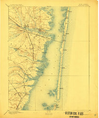
1898 Map of Barnegat
USGS Topo · Published 1911About this map
The barrier islands and cedar-swamp coast of Ocean County are captured here just before the era of intensive seaside development. Barnegat Bay dominates the center of the sheet, separating the mainland settlements from a thin ribbon of coastal communities like Lavallette and Seaside Park. A network of Life Saving Stations, including L.S. Station Chadwick and L.S. Station Forked River, stands watch along the Atlantic shore, reflecting the maritime hazards of the late 19th century.
Find a feature on this map
54 named features on this map. Tap any name to fly to it.
Don’t see what you’re looking for? This feature index may not catch every label — zoom into the map to look around manually.
Map Details
Editions of this 1898 Barnegat Map
5 editions found

Other maps of this area

1884 · Whitings
USGS Topo · 1:62,500

1888 · Barnegat
USGS Topo · 1:62,500

1888 · Little Egg Harbor
USGS Topo · 1:62,500

1888 · Asbury Park
USGS Topo · 1:62,500

1888 · Cassville
USGS Topo · 1:62,500

1888 · Long Beach
USGS Topo · 1:62,500

1888 · Whitings
USGS Topo · 1:62,500

1893 · Little Egg Harbor
USGS Topo · 1:62,500

1893 · Asbury Park
USGS Topo · 1:62,500

1893 · Long Beach
USGS Topo · 1:62,500