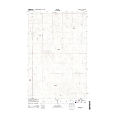
2014 Map of Barnes Butte
USGS Topo · Published 2014About this map
Barnes Butte and the Pot Hills define the topography of this section of Douglas County, characterized by a structured grid of rural agricultural roads. The landscape is surveyed under the Public Land Survey System, with township boundaries for t27n r27e and t26n r27e clearly marking the transition between sections. The road network, including Hayden Rd NE and Blake Rd NE, suggests a region dedicated to dryland farming or ranching, where large tracts of land are accessed by alphabetized and numbered routes like L Rd NE and Road 14 NE. Local landmarks like Hawks Cliff Rd NE provide specific points of interest within the vast open country of central Washington.
Find a feature on this map
23 named features on this map. Tap any name to fly to it.
Don’t see what you’re looking for? This feature index may not catch every label — zoom into the map to look around manually.
Map Details
Editions of this 2014 Barnes Butte Map
This is the sole edition of this map. No revisions or reprints were ever made.
Other maps of this area

1930 · Grand Coulee Sheet 3
USGS Topo · 1:31,680

1953 · Ritzville
USGS Topo · 1:250,000

1959 · Ritzville
USGS Topo · 1:250,000

1965 · Ritzville
USGS Topo · 1:250,000

1965 · St. Andrews
USGS Topo · 1:24,000

1965 · Jameson Lake East
USGS Topo · 1:24,000

1965 · Mold
USGS Topo · 1:24,000

1968 · Coleman Hill
USGS Topo · 1:24,000
1968 · Barnes Butte
USGS Topo · 1:24,000

1968 · Foster Coulee
USGS Topo · 1:24,000