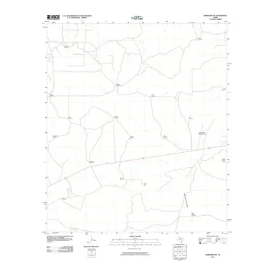
2010 Map of Barnhart NE
USGS Topo · Published 2010About this map
Wind-powered water infrastructure defines this ranching landscape in Irion County, where a vast network of named windmills supports livestock operations across the arid terrain. The map identifies numerous specific locations such as Fivemile Windmill, Ratliff Windmill, and Brooks Windmill, reflecting the essential nature of groundwater management in West Texas. At the eastern edge, the Noelke Ranch Airport highlights the necessity of private aviation for transportation and ranch oversight in this expansive region.
Find a feature on this map
22 named features on this map. Tap any name to fly to it.
Don’t see what you’re looking for? This feature index may not catch every label — zoom into the map to look around manually.
Map Details
Editions of this 2010 Barnhart NE Map
This is the sole edition of this map. No revisions or reprints were ever made.
Other maps of this area

1895 · Sherwood
USGS Topo · 1:125,000

1920 · Barnhart
USGS Topo · 1:62,500

1921 · Ketchum Mountain
USGS Topo · 1:62,500

1922 · Barnhart
USGS Topo · 1:62,500

1923 · Ketchum Mountain
USGS Topo · 1:62,500

1954 · San Angelo
USGS Topo · 1:250,000

1958 · San Angelo
USGS Topo · 1:250,000

1965 · San Angelo
USGS Topo · 1:250,000
1971 · Barnhart SW
USGS Topo · 1:24,000

1971 · Noelke
USGS Topo · 1:24,000