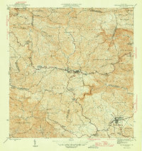
1946 Map of Barranquitas
USGS Topo · Published 1946About this map
Barranquitas serves as the central hub of this mid-century survey, surrounded by a complex network of schools and agricultural settlements in the interior mountains of Puerto Rico. The landscape is defined by its educational infrastructure, with numerous second-unit schools such as Escuela Segunda Unidad de Botijas No 2 and Escuela Segunda Unidad de Palo Hincado serving rural barrios like Botijas and Palo Hincado. In the southern portion of the map, the town of Aibonito is split into Pueblo Norte and Pueblo Sud, marking a significant population center near the Río Aibonito. The presence of Hacienda Córcega and various named ridges such as Asomante reflect the region's agricultural roots and steep topography. Waterways like the Río Usabón and Río Barranquitas carve through the terrain, illustrating the natural boundaries between municipal districts in the 1940s.
Find a feature on this map
71 named features on this map. Tap any name to fly to it.
Don’t see what you’re looking for? This feature index may not catch every label — zoom into the map to look around manually.
Map Details
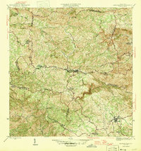
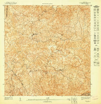
Editions of this 1946 Barranquitas Map
3 editions found
Other maps of this area

1945 · Rio Descalabrado
USGS Topo · 1:30,000

1946 · Coamo
USGS Topo · 1:30,000

1946 · Corozal
USGS Topo · 1:30,000

1946 · Barranquitas
USGS Topo · 1:30,000

1946 · Ciales
USGS Topo · 1:30,000

1946 · Cayey
USGS Topo · 1:30,000

1946 · Comerio
USGS Topo · 1:30,000

1946 · Naranjito
USGS Topo · 1:30,000

1946 · Orocovis
USGS Topo · 1:30,000
1947 · Corozal SO
USGS Topo · 1:10,000
Featured Places
- Aibonito, Aibonito
- Barranquitas, Barranquitas
- Sector Los Pinos, Aibonito
- Parcelas de Helechal, Barranquitas
- Comunidad Bárbara Santiago, Barranquitas