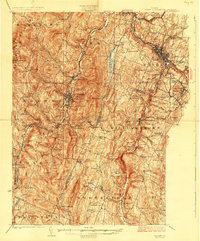
1924 Map of Barre
USGS Topo · Published 1924About this map
Norwich University stands at the heart of Northfield, a central anchor in a landscape defined by steep ridges and narrow river valleys during the early 1920s. The regional economy of central Vermont is visible through the infrastructure of the Vermont Central RR, which follows the path of the Dog River, and the heavy industrial presence of the Marble Quarry and Talc Mine. To the east, the city of Barre appears as a dense hub near Millstone Hill, supported by the Montpelier and Wells River RR. The survey reveals a dense network of district schools, such as Rabbit Hollow School and Cram Hill School, serving the upland farming and quarrying communities. Specialized facilities like the State Fish Hatchery in Roxbury and the County Hospital near Beckley Hill reflect the institutional development of the era.
Find a feature on this map
132 named features on this map. Tap any name to fly to it.
Don’t see what you’re looking for? This feature index may not catch every label — zoom into the map to look around manually.
Map Details
Editions of this 1924 Barre Map
5 editions found

Other maps of this area

1896 · Strafford
USGS Topo · 1:62,500

1915 · Rochester
USGS Topo · 1:62,500

1917 · Rochester
USGS Topo · 1:62,500

1919 · Royalton
USGS Topo · 1:62,500

1919 · Lincoln Mountain
USGS Topo · 1:62,500

1919 · Montpelier
USGS Topo · 1:62,500

1920 · Lincoln Mountain
USGS Topo · 1:48,000

1921 · Richmond
USGS Topo · 1:48,000

1921 · Lincoln Mountain
USGS Topo · 1:62,500

1921 · Montpelier
USGS Topo · 1:62,500