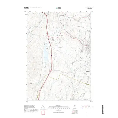
2018 Map of Barre West
USGS Topo · Published 2018About this map
The rugged terrain between Montpelier and Barre is defined by the steep valleys of the Winooski River and Stevens Branch in this modern-era survey. The map details the developed corridor of South Barre and the centralized infrastructure surrounding the Edward F Knapp State Airport. Higher elevations are marked by scattered rural cemeteries that speak to the region's earlier agricultural roots, including the Berlin Cem near Berlin Corners and the Saint Monica Cem on the outskirts of the granite-rich city. Significant water features like the expansive Berlin Pond and the Bolster Reservoir dominate the central basin, while prominent peaks like Paine Mtn and Irish Hill shape the western skyline. This geography illustrates the concentration of Vermont's population and transportation networks within the narrow, fertile valleys of Washington County, showing how historical settlements evolved around the river-and-road connections that link the capital to its neighbors.
Find a feature on this map
115 named features on this map. Tap any name to fly to it.
Don’t see what you’re looking for? This feature index may not catch every label — zoom into the map to look around manually.
Map Details
Editions of this 2018 Barre West Map
This is the sole edition of this map. No revisions or reprints were ever made.
Other maps of this area

1919 · Montpelier
USGS Topo · 1:62,500

1921 · Montpelier
USGS Topo · 1:62,500

1922 · Barre
USGS Topo · 1:48,000

1924 · Barre
USGS Topo · 1:62,500

1939 · Plainfield
USGS Topo · 1:48,000

1940 · Plainfield
USGS Topo · 1:62,500

1943 · Plainfield
USGS Topo · 1:62,500

1944 · Montpelier
USGS Topo · 1:62,500

1947 · Corinth
USGS Topo · 1:62,500

1948 · East Barre
USGS Topo · 1:62,500