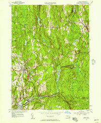
1954 Map of Barre
USGS Topo · Published 1957About this map
The Ware River and its numerous tributaries, including the Burnshirt River and Prince River, define the industrial and agricultural landscape of central Worcester County. Near the village of Barre, the terrain is marked by the Quabbin Aqueduct, which cuts across the township with critical infrastructure like Shaft 8 and Shaft 9 indicated. This mid-century survey shows the area's transition into a managed forest and water-protection zone, evidenced by the Hubbardston State Forest and Barre State Forest as well as the Barre Town Res. Genealogy researchers will find several well-defined burial grounds such as Glen Valley Cem and Nightingale Cem, while the rail history is preserved through the route of the Boston and Maine Railroad passing through Coldbrook Springs. Industrial remnants persist at Powder Mill Pond and Barre Falls, illustrating the region's long-standing relationship with water power.
Find a feature on this map
82 named features on this map. Tap any name to fly to it.
Don’t see what you’re looking for? This feature index may not catch every label — zoom into the map to look around manually.
Map Details
Editions of this 1954 Barre Map
4 editions found
Other maps of this area

1885 · Worcester
USGS Topo · 1:62,500

1886 · Worcester
USGS Topo · 1:62,500

1887 · Winchendon
USGS Topo · 1:62,500

1887 · Barre
USGS Topo · 1:62,500

1887 · Fitchburg
USGS Topo · 1:62,500

1889 · Fitchburg
USGS Topo · 1:62,500

1889 · Barre
USGS Topo · 1:62,500

1890 · Winchendon
USGS Topo · 1:62,500

1892 · Worcester
USGS Topo · 1:62,500

1893 · Fitchburg
USGS Topo · 1:62,500