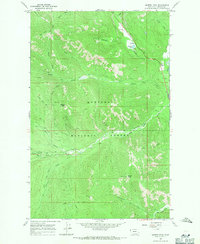
1966 Map of Barren Peak
USGS Topo · Published 1971About this map
The Kootenai National Forest dominates this mid-1960s topographic study, showcasing a high-elevation landscape defined by drainage networks and pack trails. The area is characterized by the confluence of numerous mountain streams, including Swamp Creek, Miller Creek, and West Fisher Creek, which eventually feed the larger Fisher River. Resource extraction and forest management are evident through the presence of the Waylett Mine and various Prospects located near the South Fork of Miller Creek, while a Lookout Tower atop Barren Peak indicates the primary fire suppression infrastructure of the era. High-country access in this period relied heavily on an extensive system of pack routes, such as the Libby Divide Trail and the Iron Meadow Trail. These paths connect isolated water bodies like Schrieber Lake and Bramlet Lake, providing a detailed look at the backcountry infrastructure prior to modern road expansion.
Find a feature on this map
31 named features on this map. Tap any name to fly to it.
Don’t see what you’re looking for? This feature index may not catch every label — zoom into the map to look around manually.
Map Details
Editions of this 1966 Barren Peak Map
2 editions found
Other maps of this area

1920 · Libby
USGS Topo · 1:125,000

1920 · Jennings
USGS Topo · 1:125,000

1930 · Libby
USGS Topo · 1:125,000

1932 · Libby
USGS Topo · 1:125,000

1932 · Trout Creek
USGS Topo · 1:125,000

1935 · Thompson Lakes
USGS Topo · 1:96,000

1935 · Trout Creek
USGS Topo · 1:125,000

1936 · Trout Creek
USGS Topo · 1:125,000

1937 · Thompson Falls
USGS Topo · 1:125,000

1942 · Thompson Lakes
USGS Topo · 1:125,000