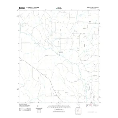
2012 Map of Barrineau Park
USGS Topo · Published 2012About this map
The Perdido River serves as a natural boundary along the western edge of this Florida-Alabama borderland, where the rural settlements of Barrineau Park and Tenile define the local landscape. The map reveals a community organized around family and agricultural road networks, including Pugh Chapel Rd, Crabtree Church Rd, and Barrineau Park School Rd, pointing toward the traditional pillars of local life. The terrain is intricately dissected by a dense network of tributaries such as Cowhide Cr, McDavid Cr, and Alligator Cr. Toward the northeast, Sunny Hill marks a point of higher ground, while the inclusion of Four Star Farm Rd suggests the continued importance of large-scale agriculture in this region during the early 21st century.
Find a feature on this map
62 named features on this map. Tap any name to fly to it.
Don’t see what you’re looking for? This feature index may not catch every label — zoom into the map to look around manually.
Map Details
Editions of this 2012 Barrineau Park Map
This is the sole edition of this map. No revisions or reprints were ever made.
Other maps of this area

1920 · Robertsdale
USGS Topo · 1:62,500

1921 · Muscogee
USGS Topo · 1:62,500

1941 · Muscogee
USGS Topo · 1:62,500

1941 · Robertsdale
USGS Topo · 1:62,500

1941 · Century
USGS Topo · 1:62,500

1942 · Dyas
USGS Topo · 1:62,500

1943 · Robertsdale
USGS Topo · 1:62,500

1943 · Muscogee
USGS Topo · 1:62,500

1943 · Century
USGS Topo · 1:62,500
1944 · Muscogee
USGS Topo · 1:25,000