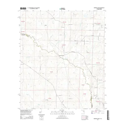
2015 Map of Barrineau Park
USGS Topo · Published 2015About this map
The Perdido River carves a winding natural boundary between Florida and Alabama, defining the central landscape of this western Panhandle survey. Along its eastern banks, the settlement of Barrineau Park serves as a local hub, connected by a network of rural routes including Barrineau Park Rd and Cr-196. The terrain is deeply etched by numerous tributaries such as Alligator Cr, Cowdevil Cr, and Loggerhead Cr, which drain the timbered and agricultural lands surrounding Sunny Hill and Tenile. This area reflects a quiet interior economy driven by farmsteads and rural residency, with landmarks like Pugh Chapel Rd and Solari Farm Rd indicating the long-standing family presence in northern Escambia County. To the south, the landscape opens toward Bellefontaine Cr and Bull Pen Cr, where the transition from Alabama's Baldwin County back into Florida is marked by the river's meandering course.
Find a feature on this map
76 named features on this map. Tap any name to fly to it.
Don’t see what you’re looking for? This feature index may not catch every label — zoom into the map to look around manually.
Map Details
Editions of this 2015 Barrineau Park Map
This is the sole edition of this map. No revisions or reprints were ever made.
Other maps of this area

1920 · Robertsdale
USGS Topo · 1:62,500

1921 · Muscogee
USGS Topo · 1:62,500

1941 · Muscogee
USGS Topo · 1:62,500

1941 · Robertsdale
USGS Topo · 1:62,500

1941 · Century
USGS Topo · 1:62,500

1942 · Dyas
USGS Topo · 1:62,500

1943 · Robertsdale
USGS Topo · 1:62,500

1943 · Muscogee
USGS Topo · 1:62,500

1943 · Century
USGS Topo · 1:62,500
1944 · Muscogee
USGS Topo · 1:25,000