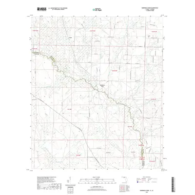
2018 Map of Barrineau Park
USGS Topo · Published 2018About this map
The Perdido River defines the winding border between Florida and Alabama in this modern survey of the Gulf Coastal Plain. The settlement of Barrineau Park serves as a local hub, connected by a network of rural routes such as Molino Rd and Barrineau Park School Rd. The landscape is intricately carved by numerous tributaries including McDavid Cr, Cowdevil Cr, and Bellefontaine Cr, which drain the low-lying terrain. To the north, the small communities of Tenile and Sunny Hill are surrounded by family-named landmarks and agricultural tracts, with roads like Crabtree Church Rd and Pugh Chapel Rd indicating the locations of historical local congregations and gathering places. This map captures the region's enduring rural character and the complex drainage patterns of the Escambia and Baldwin County borderlands.
Find a feature on this map
75 named features on this map. Tap any name to fly to it.
Don’t see what you’re looking for? This feature index may not catch every label — zoom into the map to look around manually.
Map Details
Editions of this 2018 Barrineau Park Map
This is the sole edition of this map. No revisions or reprints were ever made.
Other maps of this area

1920 · Robertsdale
USGS Topo · 1:62,500

1921 · Muscogee
USGS Topo · 1:62,500

1941 · Muscogee
USGS Topo · 1:62,500

1941 · Robertsdale
USGS Topo · 1:62,500

1941 · Century
USGS Topo · 1:62,500

1942 · Dyas
USGS Topo · 1:62,500

1943 · Robertsdale
USGS Topo · 1:62,500

1943 · Muscogee
USGS Topo · 1:62,500

1943 · Century
USGS Topo · 1:62,500
1944 · Muscogee
USGS Topo · 1:25,000