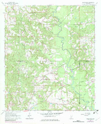
1963 Map of Barrontown
USGS Topo · Published 1982About this map
Tallahala Creek winds through this Pine Belt landscape, serving as a central geographic anchor where the borders of Jones, Forrest, and Perry Counties converge. The mapping reflects a rural Mississippi territory during the early 1960s, defined by a network of small settlements like Union, Morriston, and Barrontown. The cultural landscape is heavily punctuated by local spiritual and family sites, including Mars Hill Ch and several burial grounds such as Murphy Cem and Kirkland Cem.
Find a feature on this map
47 named features on this map. Tap any name to fly to it.
Don’t see what you’re looking for? This feature index may not catch every label — zoom into the map to look around manually.
Map Details
Editions of this 1963 Barrontown Map
4 editions found
Other maps of this area

1953 · Hattiesburg
USGS Topo · 1:250,000

1958 · Hattiesburg
USGS Topo · 1:250,000

1963 · Barrontown
USGS Topo · 1:24,000

1964 · Carterville
USGS Topo · 1:24,000

1964 · Ovett SE
USGS Topo · 1:24,000

1964 · Ovett
USGS Topo · 1:24,000

1964 · Ellisville
USGS Topo · 1:24,000

1964 · Hattiesburg
USGS Topo · 1:24,000

1964 · Lanham
USGS Topo · 1:24,000

1965 · Eastabuchie
USGS Topo · 1:24,000