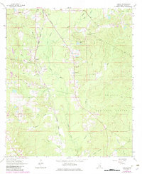
1964 Map of Lanham
USGS Topo · Published 1982About this map
Bogue Homo flows through this Mississippi landscape, providing a central drainage for numerous tributaries like Tiger Branch and Chinquapin Creek. The area is defined by its rural connectivity and public lands, with a significant portion of the territory falling within the De Soto National Forest. The Illinois Central Gulf railroad cuts through the western section of the map, passing the settlement of Lanham. Local community life is evidenced by several country churches and burial sites, including Mt Moriah Ch, Good Hope Ch, and the Tucker Cem. Public resources and conservation efforts are prominent, marked by the presence of a Fish Hatchery, Jones County Lake, and the Point Laurel Lookout Tower, which likely served as a critical fire watch point for the surrounding timberlands during this mid-century period.
Find a feature on this map
29 named features on this map. Tap any name to fly to it.
Don’t see what you’re looking for? This feature index may not catch every label — zoom into the map to look around manually.
Map Details
Editions of this 1964 Lanham Map
2 editions found

Other maps of this area

1953 · Hattiesburg
USGS Topo · 1:250,000

1958 · Hattiesburg
USGS Topo · 1:250,000

1963 · Barrontown
USGS Topo · 1:24,000

1964 · Rhodes
USGS Topo · 1:24,000

1964 · Laurel East
USGS Topo · 1:24,000

1964 · Laurel West
USGS Topo · 1:24,000

1964 · Ovett
USGS Topo · 1:24,000

1964 · Ellisville
USGS Topo · 1:24,000

1964 · Myrick
USGS Topo · 1:24,000

1964 · Strengthford
USGS Topo · 1:24,000