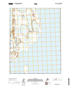
2020 Map of Barrow A-2 SW
USGS Topo · Published 2020About this map
Admiralty Bay dominates the coastal reaches of this Arctic landscape in the North Slope Borough, where the intricate shoreline reveals the shifting nature of the Alaskan coast. The map illustrates a sparse but ecologically complex environment defined by expansive wetlands and coastal inlets. Offshore, the Kikiktak Islands and the aptly named Tiny Island sit within the shallow waters, providing essential landmarks for navigation and local history. Inland, the presence of Reindeer Lake suggests the vital freshwater resources that have historically supported wildlife and subsistence patterns in this high-latitude region. The systematic grid of townships, such as t20n r14w, provides a structural contrast to the organic forms of the lagoons and islands that define this remote maritime boundary.
Find a feature on this map
11 named features on this map. Tap any name to fly to it.
Don’t see what you’re looking for? This feature index may not catch every label — zoom into the map to look around manually.
Map Details
Editions of this 2020 Barrow A-2 SW Map
This is the sole edition of this map. No revisions or reprints were ever made.
Other maps of this area

1945 · Barrow
USGS Topo · 1:250,000

1949 · Barrow
USGS Topo · 1:250,000

1951 · Teshekpuk
USGS Topo · 1:250,000

1955 · Barrow A-2
USGS Topo · 1:63,360

1955 · Barrow
USGS Topo · 1:250,000

1955 · Teshekpuk
USGS Topo · 1:250,000

1955 · Barrow A-3
USGS Topo · 1:63,360
1955 · Teshekpuk D-5
USGS Topo · 1:63,360

1955 · Teshekpuk D-4
USGS Topo · 1:63,360

1964 · Teshekpuk
USGS Topo · 1:250,000