
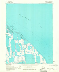
1955 Map of Teshekpuk D-4
USGS Topo · Published 1970About this map
Alaktak River winds through a landscape defined by water and ice in this 1955 survey of the Arctic coastal plain. The region, situated entirely within Naval Petroleum Reserve No. 4, shows early industrial exploration through the presence of several drill holes and a network of tractor trails that cross the tundra. Human activity is sparse but notable, centering on the settlement of Alaktak where a corral and nearby ranch suggest seasonal livestock or reindeer management. Along the northern coast, Dease Inlet and Kurgorak Bay dominate the shoreline, while the interior is a dense mosaic of thaw lakes, including the large Pittalukruak Lake. Scattered cabins provide small points of shelter for those navigating this remote environment between the Chipp R and the Piasuk River.
Find a feature on this map
18 named features on this map. Tap any name to fly to it.
Don’t see what you’re looking for? This feature index may not catch every label — zoom into the map to look around manually.
Map Details
Editions of this 1955 Teshekpuk D-4 Map
This is the sole edition of this map. No revisions or reprints were ever made.
Other maps of this area

1945 · Barrow
USGS Topo · 1:250,000

1949 · Barrow
USGS Topo · 1:250,000

1951 · Teshekpuk
USGS Topo · 1:250,000

1955 · Barrow A-2
USGS Topo · 1:63,360

1955 · Barrow
USGS Topo · 1:250,000

1955 · Teshekpuk
USGS Topo · 1:250,000

1955 · Teshekpuk C-3
USGS Topo · 1:63,360

1955 · Teshekpuk C-5
USGS Topo · 1:63,360

1955 · Teshekpuk C-4
USGS Topo · 1:63,360
1955 · Barrow A-1
USGS Topo · 1:63,360