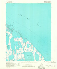
1955 Map of Barrow A-1
USGS Topo · Published 1967About this map
Sinclair Lake and the marshy expanses of the North Slope dominate this mid-century Arctic landscape, captured during a period of early energy exploration within Naval Petroleum Reserve No. 4. The map reveals a remote coastline defined by the Plover Islands chain, including Kulgurak Island and Tulimanik Island, which shelter the shallow waters of Fatigue Bay from the Beaufort Sea. Human presence is sparse but industrially significant, marked by the Simpson Test Well No 1 and a cluster of Test Wells No 13-24 near the coast. Movement across this delicate permafrost environment was dictated by a network of Tractor Trails and a designated Winter Trail, essential for navigating the terrain before permanent infrastructure. Evidence of earlier habitation or abandoned structures is noted simply as Ruins near the Sinclair River, while a remote Landing Strip provided the primary link to the outside world.
Find a feature on this map
21 named features on this map. Tap any name to fly to it.
Don’t see what you’re looking for? This feature index may not catch every label — zoom into the map to look around manually.
Map Details
Editions of this 1955 Barrow A-1 Map
This is the sole edition of this map. No revisions or reprints were ever made.
Other maps of this area

1945 · Barrow
USGS Topo · 1:250,000

1949 · Barrow
USGS Topo · 1:250,000

1951 · Teshekpuk
USGS Topo · 1:250,000

1955 · Barrow A-2
USGS Topo · 1:63,360

1955 · Barrow
USGS Topo · 1:250,000

1955 · Teshekpuk
USGS Topo · 1:250,000
1955 · Teshekpuk D-3
USGS Topo · 1:63,360

1955 · Teshekpuk D-4
USGS Topo · 1:63,360
1962 · Barrow A-1
USGS Topo · 1:50,000

1964 · Teshekpuk
USGS Topo · 1:250,000