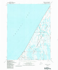
1955 Map of Barrow A-5
USGS Topo · Published 1984About this map
The Will Rogers and Wiley Post Memorial stands on the coast of the Chukchi Sea, marking the site of the 1935 air crash along this desolate Arctic shoreline. In the mid-1950s, the landscape was a mix of traditional locations and Cold War-era infrastructure, including the Loran Radio Tower (Abandoned) and Loran Radio Station (Abandoned) near Nulavik. Much of the territory falls within the National Petroleum Reserve in Alaska, where the hydrology is defined by the Walakpa River and Singaruak Creek. Inland, a network of a Winter Trail connects seasonal or small settlements like Walakpa and Sinaru, revealing the essential transportation routes used when the tundra and Kilusiktok Lake are frozen. This map documents a transitional period for the North Slope, capturing early navigational landmarks and the remote Barrow Corp Bdy at a time of increasing federal interest in Arctic resources.
Find a feature on this map
19 named features on this map. Tap any name to fly to it.
Don’t see what you’re looking for? This feature index may not catch every label — zoom into the map to look around manually.
Map Details
Editions of this 1955 Barrow A-5 Map
3 editions found
Other maps of this area

1945 · Barrow
USGS Topo · 1:250,000

1949 · Barrow
USGS Topo · 1:250,000

1951 · Meade River
USGS Topo · 1:250,000

1955 · Barrow
USGS Topo · 1:250,000

1955 · Barrow B-4
USGS Topo · 1:63,360

1955 · Meade River
USGS Topo · 1:250,000

1955 · Barrow A-4
USGS Topo · 1:63,360

1955 · Barrow A-5
USGS Topo · 1:63,360

1955 · Meade River D-2
USGS Topo · 1:63,360

1955 · Meade River D-3
USGS Topo · 1:63,360