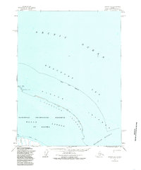
1955 Map of Barrow B-3
USGS Topo · Published 1985About this map
The North Slope Borough coast is defined here by the barrier islands and shallow waters that separate the Arctic Ocean from the protected interior. The Plover Islands and Tapkaluk Islands form a narrow, intermittent arc that shelters the broad Elson Lagoon. This coastal landscape, part of the National Petroleum Reserve in Alaska, reveals a sparse but functional network of transportation and geography at the edge of the Beaufort Sea.
Find a feature on this map
11 named features on this map. Tap any name to fly to it.
Don’t see what you’re looking for? This feature index may not catch every label — zoom into the map to look around manually.
Map Details
Editions of this 1955 Barrow B-3 Map
2 editions found
Other maps of this area

1945 · Barrow
USGS Topo · 1:250,000

1949 · Barrow
USGS Topo · 1:250,000

1955 · Barrow A-2
USGS Topo · 1:63,360

1955 · Barrow
USGS Topo · 1:250,000

1955 · Barrow B-4
USGS Topo · 1:63,360

1955 · Barrow A-4
USGS Topo · 1:63,360

1955 · Barrow A-3
USGS Topo · 1:63,360
1955 · Barrow B-3
USGS Topo · 1:63,360
1962 · Barrow B-4
USGS Topo · 1:50,000
1962 · Barrow A-4
USGS Topo · 1:50,000