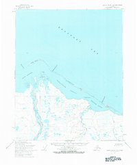
1955 Map of Barter Island A-4
USGS Topo · Published 1984About this map
Jago River and the Niguannak River snake through a water-dense landscape of tundra and thaw lakes as they reach the Arctic coast. This mid-century survey by the Army Map Service documents the intricate barrier island and lagoon systems along the Beaufort Sea, a region later managed within the Arctic National Wildlife Range. The coastline is defined by elongated landforms like Jago Spit and Tapkaurak Spit, which create protected waters in the Jago Lagoon and Tapkaurak Lagoon. Geographers and researchers can trace the natural breaks in these barriers, such as Jago Entrance and Oruktalik Entrance, which dictate the coastal flow. Points of land like Martin Point and Griffin Point stand as the few distinct landmarks in this shifting maritime environment, where the John River joins a complex network of seasonal channels and wetland patterns.
Find a feature on this map
16 named features on this map. Tap any name to fly to it.
Don’t see what you’re looking for? This feature index may not catch every label — zoom into the map to look around manually.
Map Details
Editions of this 1955 Barter Island A-4 Map
3 editions found
Other maps of this area

1951 · Barter Island
USGS Topo · 1:250,000

1951 · Demarcation Point
USGS Topo · 1:250,000

1955 · Demarcation Point
USGS Topo · 1:250,000

1955 · Demarcation Point D-3
USGS Topo · 1:63,360

1955 · Barter Island A-5
USGS Topo · 1:63,360

1955 · Barter Island A-4
USGS Topo · 1:63,360
1955 · Barter Island A-3
USGS Topo · 1:63,360

1955 · Demarcation Point D-5
USGS Topo · 1:63,360

1955 · Demarcation Point D-4
USGS Topo · 1:63,360

1959 · Barter Island
USGS Topo · 1:250,000