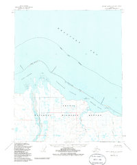
1955 Map of Barter Island A-4
USGS Topo · Published 1985About this map
The Arctic National Wildlife Refuge dominates the landscape of this coastal survey, where the terrestrial wilderness meets the cold waters of the Beaufort Sea. This 1955 photogrammetric study, updated through the 1980s, reveals a dynamic shoreline of barrier spits and shallow basins including Jago Lagoon, Tapkaurak Lagoon, and Oruktalik Lagoon. The hydrological patterns are defined by braided arctic waterways such as the Jago River, Niguarak River, and John River, which deposit sediment along the coast to form features like Jago Spit. Located within the North Slope Borough, the area shows no roads or trails, illustrating a preserve where geography is dictated by seasonal ice, river flow, and points of land like Martin Point and Griffin Point.
Find a feature on this map
17 named features on this map. Tap any name to fly to it.
Don’t see what you’re looking for? This feature index may not catch every label — zoom into the map to look around manually.
Map Details
Editions of this 1955 Barter Island A-4 Map
3 editions found
Other maps of this area

1951 · Barter Island
USGS Topo · 1:250,000

1951 · Demarcation Point
USGS Topo · 1:250,000

1955 · Demarcation Point
USGS Topo · 1:250,000

1955 · Demarcation Point D-3
USGS Topo · 1:63,360

1955 · Barter Island A-5
USGS Topo · 1:63,360

1955 · Barter Island A-4
USGS Topo · 1:63,360
1955 · Barter Island A-3
USGS Topo · 1:63,360

1955 · Demarcation Point D-5
USGS Topo · 1:63,360

1955 · Demarcation Point D-4
USGS Topo · 1:63,360

1959 · Barter Island
USGS Topo · 1:250,000