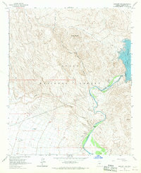
1964 Map of Bartlett Dam
USGS Topo · Published 1970About this map
The Bartlett Reservoir and the Verde River dominate this desert landscape within the Tonto National Forest. Mapping conducted in 1962 and field-checked in 1964 reveals the critical water infrastructure of the Salt River Project, centered on the Bartlett Dam and its associated Gaging Station. The terrain is defined by complex drainage systems such as Bootleg Canyon and Indian Spring Wash, which feed into the river valley below Brushy Mountain. Local ranchers and travelers of the mid-1960s relied on a network of remote water sources including Buckhorn Tank and the uniquely named Model A Tank. Distinctive landmarks like Needle Rock stand out along the river's winding path, while numerous jeep trails provide the only terrestrial access through the dissected hills and sandy washes of this Maricopa County wilderness.
Find a feature on this map
18 named features on this map. Tap any name to fly to it.
Don’t see what you’re looking for? This feature index may not catch every label — zoom into the map to look around manually.
Map Details
Editions of this 1964 Bartlett Dam Map
3 editions found
Other maps of this area

1904 · Camelback
USGS Topo · 1:62,500

1904 · Ft. McDowell
USGS Topo · 1:62,500

1906 · Camelsback
USGS Topo · 1:62,500

1906 · Ft. McDowell
USGS Topo · 1:62,500

1930 · Cave Creek
USGS Topo · 1:125,000

1939 · Cave Creek
USGS Topo · 1:125,000

1954 · Mesa
USGS Topo · 1:250,000

1957 · Mesa
USGS Topo · 1:250,000

1958 · Mesa
USGS Topo · 1:250,000

1960 · Mesa
USGS Topo · 1:250,000