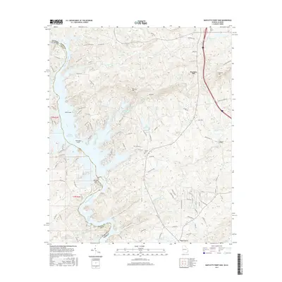
2017 Map of Bartletts Ferry Dam
USGS Topo · Published 2017About this map
Bartletts Ferry Dam anchors this stretch of the Chattahoochee River, where the waters of Bartletts Ferry Lake and Lake Harding form a complex shoreline between Georgia and Alabama. The landscape is defined by its hydroelectric history and the winding inlets of Mulberry Creek and Wacoochee Creek. On the Georgia side, the terrain rises toward several notable peaks including Williams Mtn, German Mtn, and the ridge of Pine Mtn. Small communities like Mountain Hill and Piney Grove serve as local hubs, while historical burial grounds such as Antioch Cem and Old Smyrna Cem provide essential data points for family researchers. The map traces the transition from the river bottomlands to the higher elevations of Mountain Oak Creek, revealing a rural network of roads and small private lakes like Lake Williams and Peterson Lake that characterize this border region in the early twenty-first century.
Find a feature on this map
106 named features on this map. Tap any name to fly to it.
Don’t see what you’re looking for? This feature index may not catch every label — zoom into the map to look around manually.
Map Details
Editions of this 2017 Bartletts Ferry Dam Map
This is the sole edition of this map. No revisions or reprints were ever made.
Other maps of this area

1907 · Talbotton
USGS Topo · 1:125,000

1907 · Opelika
USGS Topo · 1:125,000

1909 · Opelika
USGS Topo · 1:125,000

1950 · Fortson
USGS Topo · 1:24,000

1950 · Mulberry Grove
USGS Topo · 1:24,000

1950 · Ellerslie
USGS Topo · 1:62,500
1955 · Mulberry Grove
USGS Topo · 1:24,000
1955 · Fortson
USGS Topo · 1:24,000
1955 · Ellerslie
USGS Topo · 1:62,500

1955 · Phenix City
USGS Topo · 1:250,000